By Brian Lepping, Project Lead
The Tribal Resource Stewardship Division is currently conducting a feasibility study on the Middle Yukon River that will use sonar to count salmon as they migrate through to their spawning grounds. Currently, the Alaska Department of Fish and Game (ADF&G) operates two similar sonar counting stations: one in the Lower Yukon at Pilot Station and one in the Upper Yukon located near Eagle. These counting stations are used to provide fisheries managers with needed in-season information to direct management actions towards the fishery. TCC and its member Tribes are currently building Tribal scientific capacity by conducting the required feasibility efforts that will lead to the eventual operation of a sonar assessment project located in the Middle Yukon River. The project may eventually provide fisheries managers with information that can be used for improved in-season fisheries management actions. The feasibility efforts started in early 2023 when TCC hired a fisheries biologist to lead the sonar feasibility study.
Choosing a Site
The next step in the feasibility process was to locate some potential sites suitable for a sonar operation. A few of the key aspects that were looked for when identifying an appropriate section of a river included:
- A single, unbraided, and relatively narrow channel
- Smooth sloping and mostly linear river bottom profile
- Suitable river characteristics related to flow and bottom substrates
- Proximity to villages for project support
Using a combination of satellite imagery and local traditional knowledge, eight potential sites were located between the Bridge and Galena. In late July 2023, TCC contracted with Yukon River Transport to investigate each site thoroughly using sonar to make “maps” of the river bottom. Using latitude, longitude, and depth readings, we were able to produce the images below.
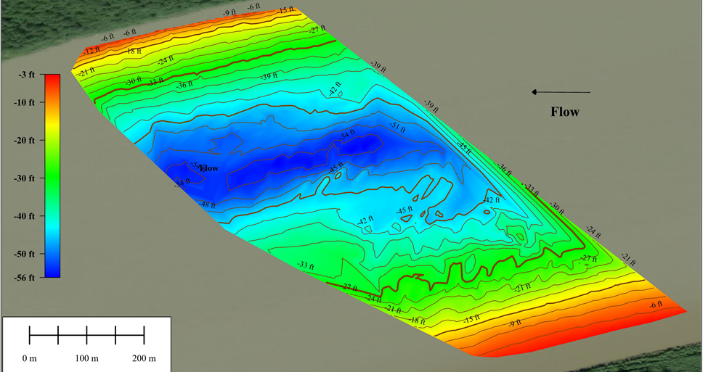
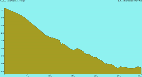
The image on the left shows a map of the depth profile at one of the locations where we collected data. It also shows what the land is like underneath the water. The image on the right is a cross-sectional view of the left descending bank. It is the view of the river bottom if we were looking directly upstream or downstream.
The sonar was also capable of viewing objects underneath the water that might obstruct sonar operations. We scanned near the shore at most of the sites to look for boulders, debris, or anything that could prevent the sonar from “seeing” passing fish. It produced images like the following:
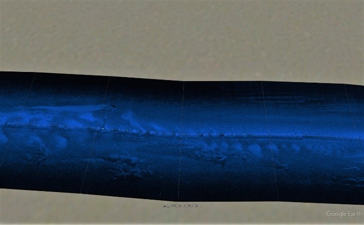
On the left we have an image of what seems to be sand ripples with root wads embedded within the sand. This could potentially cause issues when we deploy sonar to count fish. On the right we have an image of what appears to be a smooth and debris-less bottom. These are just snapshots of what is visible at the time we were there. Images like these simply allow us to know what to expect when we visit these locations for further testing.
After generating these images of our eight selected sites and using the data we collected, we chose which sites we want to evaluate further in 2024. This year, we will revisit 2-3 of the sites selected. We are currently working with ADF&G and the U.S. Fish and Wildlife Service (USFWS) to borrow sonar equipment for the 2024 field season. During the coming summer months, we will be deploying sonar at each proposed site with the hopes of answering some basic questions to help us determine whether we can use sonar to effectively count migrating salmon in the Middle Yukon. In addition to gathering the information needed for this study in the coming years, we also hope to increase Tribal scientific capacity and to develop a permanent sonar project on the Middle Yukon River.